
|
|
||||||||||||||||||


| Download the revised decree and electoral calendar, published in the official journal |

|
 |
|
|
|
|
|
|
|||||||
|
|
Haiti - FLASH : Matthew, Hurricane Category 4 (UPDATE 4:50 p.m.) 30/09/2016 14:13:37
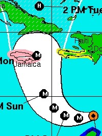
UPDATE 4:50 p.m. : NOAA informs that the hurricane Matthew is now a Category 4 with maximum sustained winds of 220 km/h, and is currently moving towards the west southwest at 15 km/h. A Tropical Storm Watch has been issued for the southwestern coast of Haiti from the southern border with the Dominican Republic to Port-Au-Prince. Tropical storm conditions are possible in the watch area in Haiti by late Sunday. Rainfall totals of 10 to 15 inches (254mm - 380 mm) with isolated maximum amounts of 25 inches (635 mm) are expected across Jamaica and southern and southwestern Haiti. === The National Hurricane Center of NOAA (National Oceanic and Atmospheric Administration), informs that the hurricane Matthew is now a Category 3, it is located 550 km southeast of Port-au-Prince, with maximum sustained winds of 195 km/h, and is currently moving towards the west southwest at 19 km/h. However, according to forecasts, Matthew should initiate a turn to the north in of Saturday, and start affecting the extreme west Haitian coast from Sunday or Monday. For now, the National Meteorological Centre (CNM) of Haiti indicates that the CNM could go into alert phase from one moment to the other. The National Society of the Haitian Red Cross (CRH), says there are threats of serious flooding in coastal communities located less than 3.00 meters above the level of the sea. The sea level may rise on the whole side of the Bay of Gonaïves. CRH suggests taking preventive measures for the Coastal South from Anse-a-Pitre until the Windward Passage, not to mention other areas at risk. HL/ HaitiLibre
|
|









|
|
Why HaitiLibre ? |
Contact us |
Français
Copyright © 2010 - 2026 Haitilibre.com |