Haiti - FLASH : Dorian gets closer, Haiti goes on yellow alert
27/08/2019 10:01:10
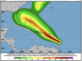
Tropical Storm Dorian continues to move on a west-northwest course. According to the Monday night report from the US National Hurricane Center (NHC) Dorian's speed has dropped slightly from 22 km / h to 20 km / h with steady winds from 95 km / h to 85km / h. Monday night, Dorian was located about 95 km south-east of Barbados (Lesser Antilles) at 12.7 degrees North Latitude and 58.8 degrees West Longitude. On the Caribbean Arc, Saint Lucia has suspended its alert level. Barbados, Martinique and Saint Vincent and the Grenadines maintain their alert level while Dominica, Grenada and Puerto Rico maintain their level of vigilance. On Wednesday, Dorian, which could become a Category 1 Hurricane, will move closer to Haiti and the first effects could begin to be felt in the coastal region and northern Haiti as early as Thursday night or Friday. However, Dorian could weaken a little, after touching the western part (East Point) of the Dominican Republic. As a result, in the face of threats of heavy rains and strong winds, with the risk of landslides, swells, landslides and floods that could be caused by the system during its passage in the vicinity of the northern coastal regions of Haiti, the Hydro Unit Meteorological Haiti in concert with the Directorate of Civil Protection is the SPGRD triggered the National Plan for Risk Management and Disasters Monday, August 26 at 6:00 pm at Vigilance Yellow (ie risk of impact Low to moderate intensity) SL/ HaitiLibre
|