
|
|
||||||||||||||||||
| Download the revised decree and electoral calendar, published in the official journal |

|
|
|
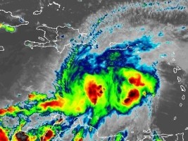
Haiti - FLASH : Storm Franklin, Haiti on Yellow Alert 21/08/2023 17:11:19
This Monday at 5:00 pm the center of tropical storm Franklin is located at 14.3° North 70.1° West, 450km south of Santo Domingo, 492km southeast of Cayes-Jacmel and 520km southeast of Port-au-Prince. Franklin is moving slowly west at nearly 5 mph (7 km/h), and a slow westward motion is expected tonight. A sharp northerly turn is expected on Tuesday and this general movement will continue through Wednesday. On the forecast track, the center of Franklin is expected to reach the southern coast of Hispaniola on Wednesday morning. Maximum sustained winds remain near 50 mph (85 km/h) with stronger gusts. Some reinforcement is expected before Franklin reaches Hispaniola. Tropical storm-force winds extend outward up to 110 km from the center. A tropical storm warning is in effect for : the entire southern coast of the Dominican Republic from the Haiti border eastward to Isla Saona; Haiti the entire southern coast from Anse d'Hainault eastward to the border with the Dominican Republic. A tropical storm watch is in effect for : Dominican Republic along the entire north and east coast from the Haiti border eastward and southward to Isla Saona; the Turks and Caicos Islands. The Directorate General of Civil Protection, the Hydro-Meteorological Unit of Haiti (UHM) in concert with the Permanent Secretariat for Disaster Risk Management, has decided to put Haiti on Yellow Alert due to the passage of tropical storm Franklin overnight from Tuesday to Wednesday. This vigilance is maintained due to the high risks of heavy rains, powerful winds, rockslides, large swells, landslides and floods during the passage of the tropical storm. According to the Hydrometeorological Unit of Haiti, the center of tropical storm Franklin should first impact the southern peninsula of the country, in particular the departments of South, Grand'Anse and Nippes, as well as spread to other departments of the country, from Tuesday evening. The passage of the center of the storm is expected on the island of Haiti by Wednesday. The southern peninsula of Haiti is threatened by torrential rains, gusty winds and rough sea conditions from Tuesday evening. These threats are expected to spread across the country on Wednesday. For precipitation level Franklin is expected to produce 2 to 4 inches (5 to 10 cm) of rain amounts, with isolated higher amounts of 6 inches, across Puerto Rico through the middle of the week. Rainfall amounts of 5 to 10 inches (12.5 to 25 cm), with isolated higher amounts up to 15 inches (38cm), will be possible over parts of Hispaniola. For the wind, tropical storm conditions are expected to begin in the warning zone on Tuesday and are possible in the watch zone from late Tuesday through Wednesday. A storm surge will cause water levels to rise up to 1 to 3 feet (30 to 90cm) above ground level along the immediate coastline near and east of where the center makes landfall in Hispaniola. HL/ HaitiLibre
|
|


|
Why HaitiLibre ? |
Contact us |
Français
Copyright © 2010 - 2026 Haitilibre.com |